Jessica Chandras, PhD (University of North Florida)
j.chandras@unf.edu
Devayani Tirthali, PhD (Independent Scholar)
dgt2103@columbia.edu
Priya Dabak, MA (Independent Scholar)
priyadabak@gmail.com
NEOS Issue 15, Volume 2, Fall 2023
Return to Current Issue Table of Contents
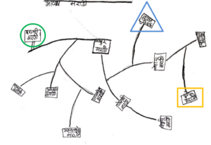
“I am only drawing the places where Marathi is spoken,” Rekha1 told her friends as they drew maps in their school dormitory on a leisurely weekend in July 2022. Marathi is the official language of the western Indian state of Maharashtra. Rekha and the majority of her peers belong to a Denotified Tribe community across India whose name and language are both called Banjara. Multilingual Banjara students in rural Maharashtra navigate a setting that includes schools where the language of instruction is not the language spoken in their socially and linguistically segregated hamlets, known as tandas (Ramaswamy and Bhukya 2002; Shah and Bara 2020). We asked the girls and young women between the ages of 11 and 17, to draw a freehand map that showed their understanding of places surrounding them and languages that they use or know to be used in those locations. As researchers, we are non-Banjara women from Marathi and English-speaking urban backgrounds and while the young women freely spoke in Banjara amongst themselves, we spoke Marathi with them. Our gender made it possible to spend time with the girls and young women who drew the maps in their female-only dormitory. Out of 23 maps, we explore four which most clearly help us to understand how Banjara youth make sense of their identities within a multilingual landscape and its spatial organization through language. Not only do we consider how Banjara children and youth understand places that they navigate on a regular basis, such as their home tanda, other villages, and school, but also how language negotiations are a part of that process.
Mapping is both a method and frame to analyze connections between space, emotions, and processes that shape children’s identities and how they make sense of everyday life (Gillespe 2010; Lowes 2008; Lynch 1960). As a qualitative method, individuals with insider knowledge of a location are asked to externalize a mental spatial schema by drawing a particular area and significant places from memory to create an intimate view of a location (Graham 1976; Veronese et al. 2022). Children and adolescents’ maps reveal their perceptions of cultural boundaries and sensitivities which may be difficult for adults to perceive (Gillespe 2010). Bringing mapping practices into our linguistic anthropological research makes visible the young women and girls’ relative relationships and community membership organized around languages as cultural categories (Catling 1979; Duranti and Goodwin 1992; Feld and Basso 1996). Making sense of a multilingual environment for these young women includes 1) orienting and organizing knowledge of places through varying degrees of familiarity, and 2) determining sociality and social distance through spatial (dis)connections from linguistic communities. Our interlocutors were non-English speakers and wrote on their maps in Devanagari, a script adopted for some Indian languages.
Sense of Self, Belonging, and Familiarity
While researching geographic literacy, Lowes (2008) found that when American 3rd and 4th graders drew world maps, the places they had emotional connections to become larger, more central, or more detailed than other places. This shows what Lowes (2008) calls “ego-centric place knowledge” (10) where aspects of the landscape are drawn with greater detail according to the authors’ relationships with them.
Rehka’s insistence on only drawing locations where Marathi is spoken meant that she left her home tanda off the map. At 13, she may have been demonstrating her geographic knowledge for us, but nevertheless, we do not see details delineating multilingualism in the landscape of Rekha’s daily life. Rekha began her Marathi map by drawing Harali, a familiar location where her school is located (in the green circle). She then drew lines like branches spanning towards the right through areas of gradual size and importance, such as market towns, district centers, and finally, the large cities of Mumbai and Pune (highlighted with a blue triangle and orange rectangle, respectively). The first branch after Harali is also more detailed than the others. Lowes (2008) explains the degrees of varying detail in children’s maps show familiarity with a location and Catling (1979) describes how authors indicate their relationships with locations through varying sizes and distances between features. Rekha had most likely visited the more detailed locations recently or more frequently than the ones she drew further from Harali. Rekha demonstrates an understanding that Marathi, as the regional language, is connected to large places of importance. Smaller villages, including her tanda, are not part of a lingua franca network, and when visiting these locations, she expects to use Marathi.
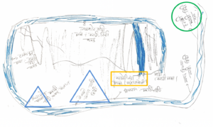
Chitra also began drawing from her present location at school in Harali (in the green circle). She does not list Banjara in Harali but instead includes Marathi, Hindi (a lingua franca in much of North India), and Kannada. Kannada is the official regional language of the neighboring state of Karnataka, and the home language of a small community of a different caste in this region. Chitra, at 17-years-old, would also be familiar with Kannada because Banjara communities and their tandas are predominantly found around the neighboring borders of Maharashtra, Telangana, and Karnataka, and many Banjara individuals travel across these state lines without the linguistic barriers non-Banjara speakers face. A snaking road wraps around the page taking the reader through places Chitra encounters on her journey to school. Importantly, she has written Banjara with her home tanda, Narkhori (in the orange rectangle). She drew her tanda at the end of the darkest and thickest line and placed it in the center but off the main road, as tanda settlements are located away from large thoroughfares. She also listed Banjara in the major towns near tandas, Jewali and Asthamod (in the blue triangles). She did not specify their tandas by name like her own, showing a different degree of familiarity with these locations (Lowes 2008).
Space, Linguistic Communities, and Social Distance
The following maps feature what Gillespie (2010) explores as children’s understanding of community spatial boundaries to highlight social distance. Physical features in the following maps show authors’ subjective associations of linguistic communities with specific places. Physical features that authors include indicate degrees of familiarity or social distance with locations and the communities who live there as defined by their dominant language.
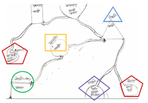
Sixteen-year-old Sushila began her map with her home tanda, Jewali Tanda (in the green circle), and labeled it only with Banjara. It is also the only location on the map where she listed Banjara. Her tanda is connected to the neighboring village, Rudrawadi (in the orange rectangle) by a long road, which she has labeled only with Marathi. Most tandas are identified with a neighboring village or town. While Sushila just calls it Jewali tanda, her tanda is alternatively called Jewali East Tanda. Although both are physically close, Sushila has placed the market town of Jewali further beyond Rudrawadi village and labeled it with Marathi. The road she takes to school makes the village of Rudrawadi seem closer than the town associated with her tanda. She has drawn roads connecting the rest of the map together and included English in the label for Harali (in the purple diamond), most likely due to us and other English speakers who frequently visit. Hindi in two locations (the red pentagon) delineates towns that Sushila understands to have a sizable Muslim community, who are often defined by their religiolinguistic use of Hindi/Urdu. Sushila categorizes the towns and tandas in different shapes corresponding with her relative familiarity with them. Veronese et al. (2022) asked children in refugee camps to categorize locations in their surroundings by color based on perceptions of their relative safety. Rather than color code, Sushila has indicated social distance by shape. The places she visits for school are drawn as circles, where she goes for a weekly market is a triangle, and larger towns where she has less familiarity, spends less time, and would use Marathi, are in a square, a cloud, and shapeless form at the end of the road in the top left corner. Such a map shows Sushila’s varied experiences of her surroundings through intricate layers of subjective meanings.
Figure 4: Map 4
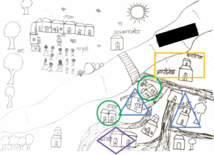
In the final map, 11-year-old Priti has drawn important features of her social environment. She mapped out her school in the top left-hand corner, including the teacher addressing a group of students. She includes a detailed map of her tanda in the lower right-hand corner and labels physical features of significance to her, such as the detached bathrooms (in green circles), her friends’ homes (in blue triangles), and a preschool (in the purple diamond). Lynch (1960) explains that commonly featured aspects across multiple maps can indicate a communal importance. On the other hand, children’s interpretations and navigation of their settings can leave out what may be expected features. While other authors drew and labeled tandas, Priti drew a close look into her tanda but did not label the tanda or her home within it. A major road separates the two halves of the map, showing physical and social distance between her school and her home. A second road separates her home from a two-story building (in the orange rectangle) that she has labeled “Building” in English written in Devanagari, demonstrating her knowledge for her English-speaking audience. Additionally, she included the label “Marathi people” on the same building. Her separation and explicit label of “Marathi people” further points to a social distance with a community defined by their dominant language. Rather than showing what Lowes (2008) calls “ego-centric place knowledge” by highlighting mundane details of her daily life, such as her own language, tanda, and home, Priti instead only includes aspects that stand out to her as exceptionally important or unique.
Conclusion
The maps explored here demonstrate subjective relationships between self, social distance, and linguistic communities in ways that highlight elements of space as cultural categories for youth (Duranti and Goodwin 1992; Feld and Basso 1996). This article’s four maps show that Banjara multilingual youth in rural India make sense of their surroundings through associations with linguistic communities and degrees of familiarity with these communities and where they are located. Learning how young people perceive multilingual landscapes brings to light daily experiences and negotiations that may go unseen by adults. Authors of these maps speak a different language at home than they must in school and broader society, demonstrating both their awareness of linguistic expectations in their surroundings and the multilingual mental schemas they use to navigate familiar and unfamiliar places (Graham 1976). Spaces are not merely dwelled in but are rather constructs of belonging and social relatedness incorporated into how one understands their own identity and position within a location and community.
Notes
1 Names have been changed. While we have permission to use these maps for research purposes, including publication, we have maintained the authors’ anonymity.
References
Catling, S. J. 1979. Maps and Cognitive Maps: The Young Child’s Perception. Geography, 64(4): 288–296.
Duranti, Alessandro, and Charles Goodwin, eds. 1992. Rethinking Context: Language as an Interactive Phenomenon. Cambridge, UK: Cambridge University Press.
Feld, Steven, and Keith H. Basso. 1996. Senses of Place. Santa Fe, New Mexico: School of American Research Press.
Gillespie, Carol Ann. 2010. How Culture Constructs Our Sense of Neighborhood: Mental Maps and Children’s Perceptions of Place, Journal of Geography, 109(1):18-29.
Graham, Elspeth. 1976. “What Is a Mental Map?” Area 8 (4): 259–62.
Lowes, Susan. 2008. “Mapping the World: Freehand Mapping and Children’s Understanding of Geography Concepts.” Research on Geography Education, 10 (2). (Research funded by the National Geographic Education Fund.)
Lynch, Kevin. 1960. The Image of the City. Cambridge, Massachusetts: The MIT Press.
Ramaswamy, Gita, and Bhangya Bhukya. 2002. “Lambadas: Changing Cultural Patterns.” Economic and Political Weekly 37 (16): 1497–99.
Shah, Ghanshyam, and Joseph Bara. (eds). 2020. Social Inclusion and Education in India: Scheduled Tribes, Denotified Tribes and Nomadic Tribes. First edition. Abingdon, Oxon; New York, NY: Routledge India.
Veronese, Guido, Federica Cavazzoni, Alec Fiorini, Hala Shoman, and Cindy Sousa. 2022. Human (in)security and psychological well-being in Palestinian children living amidst military violence: A qualitative participatory research using interactive maps. Child: Care, Health and Development. 48(1):159-169.
Author Biographies
Dr. Jessica Chandras is a linguistic anthropologist and assistant professor of anthropology at the University of North Florida. Her research interests include exploring identity construction through multilingual education in both urban and rural India. Her first book, Mother Tongue Prestige (Routledge 2024) examines privilege through the regional Indian language, Marathi, its connection to caste, and how the language is used as a teaching tool to transform student identities in English language classrooms.
Dr. Devayani Tirthali is an educational researcher and research design consultant working with early-career researchers, social-sector professionals, and NGOs. An ethnographer at heart, she focuses on the process of ‘educating in everyday living.’ Her 15 years of research spans diverse spaces online and offline: schools and afterschool programs; social media, virtual worlds, and gaming; MOOCs and online learning; and the current work with the Laman Banjara community. Over the years she has worked with a variety of research methodologies, innovatively bringing in methods from different disciplines to bear on the research project at hand.
Priya Dabak has a Master’s degree in Linguistics and has several years of experience as a language teacher in diverse K12 contexts. Her research interests focus broadly on learner agency and the dynamic language practices of multilingual learners in formal education.
Author contact: Jessica Chandras, PhD (University of North Florida), j.chandras@unf.edu; Devayani Tirthali, PhD (Independent Scholar), dgt2103@columbia.edu; Priya Dabak, MA (Independent Scholar), priyadabak@gmail.com
To cite this article: Chandras, Jessica, Devayani Tirthali, and Priya Dabak. 2023. “Mapping Multilingual Sociality in Rural India: Children and Youths’ Perceptions of Self and Language in Space.” NEOS 15 (2).
To link this article: https://acyig.americananthro.org/neosvol15iss2fall23/Chandras


